
Best Hikes on Mt Lemmon, AZ
Mt Lemmon stands at 9,159 ft in the Santa Catalina Mountain range north of Tucson, east of Oro Valley, and south of Oracle. It raises over 6,000 ft from the desert floor and is part of the Coronado National Forest and is one of the Sky Islands.
This is my absolute favorite place to go hiking in Tucson. Yes, the desert is beautiful but I'm a sucker for some conifers. While Mt Lemmon is technically the very top of the mountain, it's colloquially used when talking about this mountain range. Sometimes it's referred to as "The Lemmon" or just "The Mountain." So even a trail further down that mountain is considered to be a trail "on" Mt Lemmon.

Below are some of my favorite hiking trails on The Lemmon. Before setting out for any hike, make sure you do research, dress appropriately and have the 10 Essentials. I like to use AllTrails to get a sense of a hike and to read recent comments about trail conditions. Do not expect to have cell service and do not use your phone for navigation.
Some trailheads in the Santa Catalinas require a use fee, there will be signs indicating those fees and any other alerts. I recommend buying the Coronado National Forest Annual Pass for $40 available at the Palisades Ranger Station or Sabino Canyon Visitor Center. Dogs are allowed on all trails on Mt Lemmon but they must be leashed.
Nerd side note: Mt Lemmon is named after Sara Plummer Lemmon, a botanist and watercolor artist who along with her husband J.G. Lemmon botanized 3-4% of all the plants in Arizona (crazy right?!), as well as plants in California, Oregon, and Mexico. I highly recommend her biography "The Forgotten Botanist" by local historian Wynne Brown. Sadly because of the time she lived a lot of her discoveries were credited to her husband, or simply as "J.G. Lemmon & wife." She really lived an extraordinary life for a woman of the late 1800s. The Mt Lemmon Marigold (targetes lemonnii) is one of the plants that bears her name.
Extra fun fact: all of the Mt Lemmon Marigold plants sold in nurseries today are from the first plant Sara and her husband collected in the Huachuas in 1882!

Difficulty: Easy
Bear Wallow Trail - 2 miles out and back, 215 ft elevation gain
This is my favorite trail for fall colors! Maples, aspens, oaks, you'll find it all here. This is not an officially maintained trail but it's popular and easy to follow. You can park at the Sunset Trail gravel parking lot or at the hairpin turn on Catalina Highway, make the right hand turn onto Upper Bear Wallow Rd. Follow the dirt road until it opens up and you see a trailhead sign, about 0.25 mile.

Lemmon Meadow Loop Trail - 2.1 miles, 350 ft elevation gain
Beautiful trail at the very top of the mountain. Great views of Tucson to the south. Be prepared for lots of sun. You'll see quite a few burnt trees from the 2020 Bighorn Fire. Be sure to take the detour to the Lemmon Rock Fire Lookout. It's not open to the public, the Forest Service actually uses it, but you can get pretty close to it.

Sunset Trail to Marshall Gulch - 2.4 miles out and back, 370 ft elevation gain
Overall easy trail but some sections have rocky steps. The trail starts from the Sunset Trailhead gravel parking lot. You'll hike through a neighborhood for about 5 minutes until you start the actual trail. Lots of sun. After the trail drops down a couple hundred feed you'll see a creek, that means you're close to Marshall Gulch Trailhead.

Difficulty: Medium
Marshall Gulch/Aspen Trail Loop - 3.6 miles, 850 ft elevation gain
My favorite trail on Mt Lemmon. I love to hike it every season to see it change. Hike this loop clockwise to get the steep part over with first. Or just hike through Marshall Gulch to Marshall Saddle and back, this is what most people do. There are a couple creek crossings depending on recent rainfall. In the spring and summer you can find blooming lupines, monkey flowers, penstemons, and more. Even though it's in the pines there is a lot of sun on this trail. The Marshall Gulch Trail is part of the Arizona Trail, look for the AZT signs.


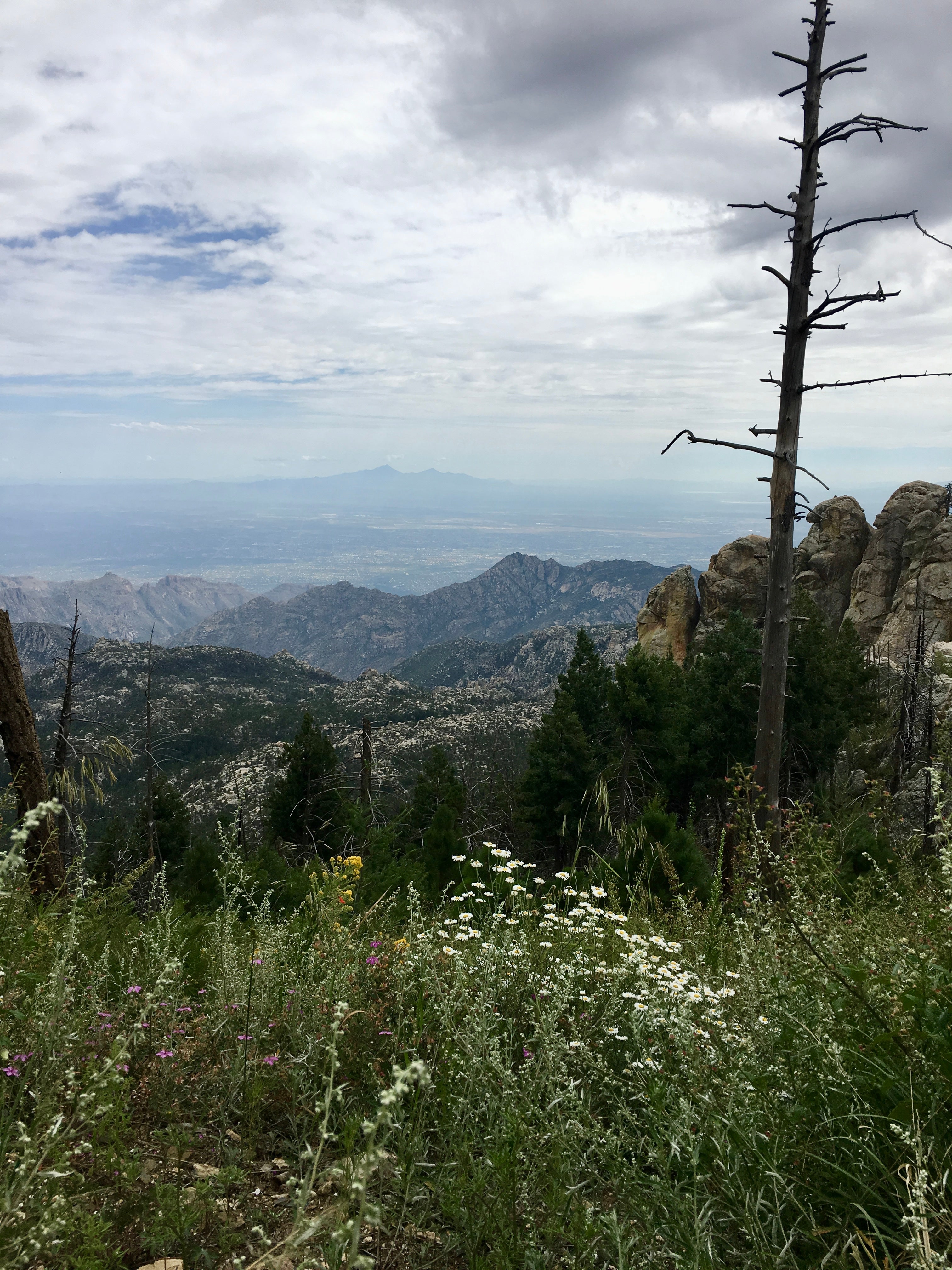
Aspen Trail to Marshall Saddle - 3.5 miles, 850 ft elevation gain
This trail drops down from the top of Mt Lemmon, past the top of the ski lift, back down to Marshall Saddle. There is a small patch of aspen trees just off trail and you can see the Lemmon Rock Fire Lookout in the distance (it's the tiny bump on the rock on the upper right side of the below photo). Marshall Saddle intersects with Marshall Gulch Trail, Aspen Trail, and Wilderness of Rocks Trail. Be prepared for the climb back up!

Sunset and Butterfly Trail Loop - 7.8 miles, 2,2000 ft elevation gain
Nice challenging hike. Be prepared for a lot of sun and carry a lot of water. Hikers get rescued from this trail in the summer for dehydration and in the winter for icy trail conditions. This trail takes you to a small waterfall and wreckage of an airplace crash, just off trail. It continues around and up to Mt Bigelow with views to the San Pedro River Valley to the east. Once you start hiking back down from Mt Bigelow you will see more mountain bikers as this is a popular unofficial mountain biking trail.

Incinerator Ridge Trail - 3.1 miles out and back, 995 ft elevation gain
You can start this at the San Pedro Lookout parking lot or up Incinerator Ridge Road, where you'll find dispersed camping and the start of the Kellogg Trail. This trail follows a ridge line with great views of the San Pedro River Valley to the east and views of Tucson to the south. Ridgelines can be windy so maybe bring a jacket. You'll see lots of wildflowers in the spring and summer months, including Mt Lemmon marigold.
And you might see some rock climbers as there are some climbing crags in this area. Be on the lookout for mountain bikers, this trail is part of the popular Lemmon Drop mountain biking trail and is also part of the Arizona Trail detour for bikers since bikes are not allowed in the wilderness area of Mt Lemmon.

Mt Bigelow Trail - 2 miles out and back, 600 ft elevation gain
Across the highway from the Palisades Visitor Center is a nice climb in the pines to the top of Mt Bigelow where radio towers sit. I recommend hiking poles since this trail can have scree and loose rocks in some areas. This trail intersects with the Kellogg Trail and the Butterfly Trail. If you take a right at the Kellogg Trail intersection there is a nice grouping of flat rocks for a shady break.

Difficulty: Hard
Wilderness of Rocks Loop - 8-10 miles, 2,370 ft elevation gain
So many trails on Mt Lemmon connect and intersect allowing you to make your own adventure. The trails in the Wilderness of Rocks are no different. You can choose to start at the summit trailheads, Lemmon Rock Lookout Trail, Aspen Trail, Marshall Gulch, etc. Depending on the day you may not see other hikers this far from the trailhead, which can be nice if you're looking for solitude on Mt Lemmon.

Red Ridge Trail - 9.5 miles out and back, 3,300 ft elevation gain
Now officially part of the Arizona Trail, this rocky, exposed trail drops you down the north side of Mt Lemmon, from the pine forest to the grasslands below. Be prepared for the rocky climb back up in mostly sun.

AZT: Passage 11: Molino Basin to Marshall Gulch - 19 miles, 5,500 ft elevation gain
Definitely not a day hike (unless you're doing the Arizona Trail) but this is a great multi day backpacking trip. You'll climb 8 miles to Romero Pass before hiking 11 miles through the Wilderness of Rocks to Marshall Gulch. One notable side adventure is to Hutch's Pool, an oasis tucked in the middle of the Pusch Ridge Wilderness.

AZT: Passage 12: Marshall Gulch to Oracle - 16.8 miles, 3,100 ft elevation gain
If your knees can handle it, this mostly downhill trail drops from the top of Mt Lemmon to the town of Oracle.
